Home · Learn · Mississippi River States
Which states does the Mississippi River touch?
The Mississippi River touches 10 states: Minnesota, Wisconsin, Iowa, Illinois, Missouri, Kentucky, Tennessee, Arkansas, Mississippi and Louisiana. It rises at Lake Itasca in northern Minnesota and flows about 2,340 miles south to the Gulf of Mexico below New Orleans. For most of that way it is a state line: nine pairs of states face each other across it.
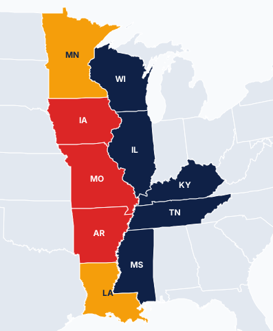
The 10 states, from source to mouth
| State | Bank | On the river | Across the river |
|---|---|---|---|
| Minnesota | Both, then west | Lake Itasca (source), Minneapolis, Saint Paul | Wisconsin |
| Wisconsin | East | La Crosse, Prairie du Chien | Minnesota, Iowa |
| Iowa | West | Dubuque, Davenport, Burlington | Wisconsin, Illinois |
| Illinois | East | Rock Island, Quincy, Cairo | Iowa, Missouri |
| Missouri | West | Hannibal, St. Louis, Cape Girardeau | Illinois, Kentucky, Tennessee |
| Kentucky | East | Wickliffe, Hickman | Missouri |
| Tennessee | East | Memphis | Missouri, Arkansas |
| Arkansas | West | Helena-West Helena | Tennessee, Mississippi |
| Mississippi | East | Vicksburg, Natchez | Arkansas, Louisiana |
| Louisiana | West, then both | Baton Rouge, New Orleans | Mississippi |
The river as a state line
From just below Saint Paul, Minnesota, to the 31st parallel, north of Baton Rouge, Louisiana, the Mississippi separates the states on its east bank from those on its west bank. The pairs, north to south, are Minnesota and Wisconsin, Iowa and Wisconsin, Iowa and Illinois, Missouri and Illinois, Missouri and Kentucky, Missouri and Tennessee, Arkansas and Tennessee, Arkansas and Mississippi, and Louisiana and Mississippi.
When the river shifts slowly, the state line moves with it; when it suddenly cuts a new channel, the line stays in the old bed. That is why a few pieces of land sit on the "wrong" side of the water. The best known oddity, the Kentucky Bend, has another cause: the Kentucky and Tennessee line was drawn across a loop of the river, leaving a piece of Kentucky cut off from the rest of the state and reached by road only through Tennessee.
Where it starts and where it ends
The river begins as a small stream flowing out of Lake Itasca, in Itasca State Park, Minnesota. It ends at the Gulf of Mexico, where it splits into channels past Head of Passes, south of New Orleans. Its basin, with its tributaries, drains all or part of 31 states and two Canadian provinces, about 40 percent of the lower 48 states.
Its main tributaries
- Missouri River, the longest river in the United States, joins just above St. Louis.
- Ohio River joins at Cairo, Illinois, and carries more water than the Mississippi above that point.
- Arkansas River joins in southeastern Arkansas.
- Illinois, Wisconsin and Minnesota rivers join in the upper river, each in the state that shares its name.
Play it on the daily grid
"On the Mississippi River" is one of the clues of the daily Statedoku puzzle.
Today's puzzleFrequently asked questions
How many states does the Mississippi River touch?
Ten: Minnesota, Wisconsin, Iowa, Illinois, Missouri, Kentucky, Tennessee, Arkansas, Mississippi and Louisiana.
Where does the Mississippi River start and end?
It rises at Lake Itasca in northern Minnesota and flows about 2,340 miles south to the Gulf of Mexico below New Orleans, Louisiana.
Which states are on the east bank of the Mississippi?
Wisconsin, Illinois, Kentucky, Tennessee and Mississippi. Iowa, Missouri and Arkansas are on the west bank, and Minnesota and Louisiana hold both banks for part of the river's course.
What are the largest tributaries of the Mississippi?
The Missouri River, which joins above St. Louis, and the Ohio River, which joins at Cairo, Illinois. The Arkansas, Illinois, Minnesota and Wisconsin rivers also flow into it.
Related guides
Last updated: