Home · Learn · US States by Time Zone (Eastern, Central, Mountain, Pacific)
US states by time zone (14 states span two zones)
The lower 48 states cover four hours from coast to coast, split into four zones: Eastern, Central, Mountain and Pacific. Add Alaska and Hawaii and you get six standard time zones for the 50 states. The tidy map falls apart in 14 states where the zone line runs through the state itself. Some states also refuse to move their clocks in March and November. Here is the full breakdown, plus which counties break the pattern and why.
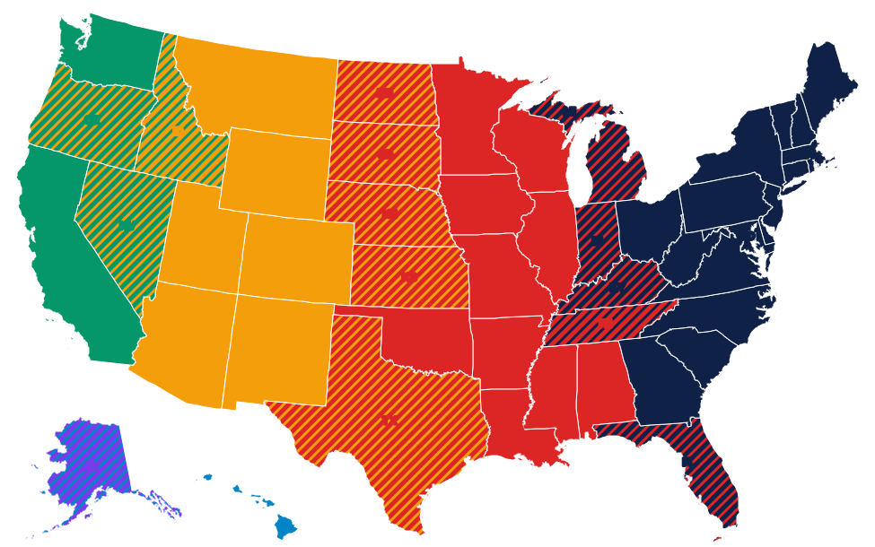
What time zone is each state in?
| State | Time zone | Which part |
|---|---|---|
| Alabama | Central | Whole state. |
| Alaska | Alaska and Hawaii-Aleutian | Alaska time almost everywhere; the Aleutian Islands west of 169.5° W on Hawaii-Aleutian time. |
| Arizona | Mountain | No daylight saving time: Mountain Standard Time all year, except the Navajo Nation, which observes it. |
| Arkansas | Central | Whole state. |
| California | Pacific | Whole state. |
| Colorado | Mountain | Whole state. |
| Connecticut | Eastern | Whole state. |
| Delaware | Eastern | Whole state. |
| Florida | Eastern and Central | Eastern for most of the state; the western Panhandle (Pensacola, Panama City) on Central. |
| Georgia | Eastern | Whole state. |
| Hawaii | Hawaii-Aleutian | No daylight saving time: Hawaii-Aleutian Standard Time all year. |
| Idaho | Mountain and Pacific | Mountain for the south (Boise); the northern panhandle (Coeur d'Alene), tied to Spokane, on Pacific. |
| Illinois | Central | Whole state. |
| Indiana | Eastern and Central | Eastern for most of the state; 12 counties, near Chicago and around Evansville, on Central. |
| Iowa | Central | Whole state. |
| Kansas | Central and Mountain | Central for almost all of it; 4 counties on the Colorado line on Mountain. |
| Kentucky | Eastern and Central | Eastern for the east (Louisville, Lexington); the western part (Bowling Green, Paducah) on Central. |
| Louisiana | Central | Whole state. |
| Maine | Eastern | Whole state. |
| Maryland | Eastern | Whole state. |
| Massachusetts | Eastern | Whole state. |
| Michigan | Eastern and Central | Eastern for almost all of it; 4 Upper Peninsula counties on the Wisconsin line on Central. |
| Minnesota | Central | Whole state. |
| Mississippi | Central | Whole state. |
| Missouri | Central | Whole state. |
| Montana | Mountain | Whole state. |
| Nebraska | Central and Mountain | Central for the east (Omaha, Lincoln); the panhandle and the counties just east of it (Ogallala) on Mountain. |
| Nevada | Pacific and Mountain | Pacific for almost all of it; West Wendover, on the Utah line, on Mountain. |
| New Hampshire | Eastern | Whole state. |
| New Jersey | Eastern | Whole state. |
| New Mexico | Mountain | Whole state. |
| New York | Eastern | Whole state. |
| North Carolina | Eastern | Whole state. |
| North Dakota | Central and Mountain | Central for most of it (Bismarck, Fargo); the southwest corner on Mountain. |
| Ohio | Eastern | Whole state. |
| Oklahoma | Central | Whole state. |
| Oregon | Pacific and Mountain | Pacific for almost all of it; most of Malheur County, in the east, on Mountain. |
| Pennsylvania | Eastern | Whole state. |
| Rhode Island | Eastern | Whole state. |
| South Carolina | Eastern | Whole state. |
| South Dakota | Central and Mountain | Central for the east (Sioux Falls, Pierre); the western half (Rapid City, the Black Hills) on Mountain. |
| Tennessee | Central and Eastern | Central for Middle and West Tennessee (Nashville, Memphis); most of East Tennessee (Knoxville, Chattanooga) on Eastern. |
| Texas | Central and Mountain | Central for almost all of it; El Paso and Hudspeth counties, in the far west, on Mountain. |
| Utah | Mountain | Whole state. |
| Vermont | Eastern | Whole state. |
| Virginia | Eastern | Whole state. |
| Washington | Pacific | Whole state. |
| West Virginia | Eastern | Whole state. |
| Wisconsin | Central | Whole state. |
| Wyoming | Mountain | Whole state. |
The six US time zones at a glance
The standard offsets from Coordinated Universal Time (UTC) are:
- Eastern (ET): UTC-5 in winter, UTC-4 in summer.
- Central (CT): UTC-6 in winter, UTC-5 in summer.
- Mountain (MT): UTC-7 in winter, UTC-6 in summer. Arizona stays on UTC-7 all year.
- Pacific (PT): UTC-8 in winter, UTC-7 in summer.
- Alaska (AKT): UTC-9 in winter, UTC-8 in summer.
- Hawaii-Aleutian (HST/HAST): UTC-10 all year in Hawaii, with DST in the far Aleutians.
States entirely on Eastern time (17)
The whole East Coast plus Vermont, Georgia, South Carolina, North Carolina and Ohio all run on Eastern time. Puerto Rico is a special case: it uses Atlantic time (UTC-4) and does not switch for daylight saving.
- Connecticut, Delaware, Georgia, Maine, Maryland, Massachusetts, New Hampshire
- New Jersey, New York, North Carolina, Ohio, Pennsylvania, Rhode Island
- South Carolina, Vermont, Virginia, West Virginia
States entirely on Central time (10)
The Midwest heartland and most of the Deep South run on Central time.
- Alabama, Arkansas, Illinois, Iowa, Louisiana, Minnesota, Mississippi, Missouri, Wisconsin, Oklahoma
Oklahoma sits fully on Central time even though it is well west of the Mississippi. It shares the zone with Chicago and Dallas.
States entirely on Mountain time (6)
The Rocky Mountain states all run on Mountain time. Arizona is the odd one out because it refuses to spring forward.
- Colorado, Montana, New Mexico, Utah, Wyoming
- Arizona (Mountain Standard Time year-round, no DST, except the Navajo Nation which does observe DST)
States entirely on Pacific time (2)
Only California and Washington are fully on Pacific time. Nevada nearly is, but West Wendover, on the Utah line, officially uses Mountain time. Oregon has a small eastern sliver on Mountain time. Idaho is split too: its northern panhandle is on Pacific.
- California, Washington
Alaska and Hawaii
Alaska is a zone of its own (UTC-9). One small piece, the Aleutian Islands west of 169.5° W, is on Hawaii-Aleutian time (UTC-10). Hawaii uses Hawaii-Aleutian Standard Time year-round without daylight saving. That means Hawaii is two hours behind California in winter and three hours behind in summer.
The 14 states that span two time zones
These states are split. In each case the smaller portion has strong economic ties to a neighboring state, which is usually why the line was drawn there.
| State | Zones | What splits |
|---|---|---|
| Alaska | Alaska + Hawaii-Aleutian | Far western Aleutians on HAST |
| Florida | Eastern + Central | Western Panhandle (Pensacola area) on Central |
| Idaho | Mountain + Pacific | Northern panhandle on Pacific, tied to Spokane |
| Indiana | Eastern + Central | 12 counties near Chicago and Evansville on Central |
| Kansas | Central + Mountain | 4 counties in the far west on Mountain |
| Kentucky | Eastern + Central | Roughly the western third (Louisville is on Eastern, but Bowling Green and Paducah are on Central) |
| Michigan | Eastern + Central | 4 Upper Peninsula counties near Wisconsin on Central |
| Nebraska | Central + Mountain | The panhandle and the counties just east of it (Ogallala) on Mountain |
| Nevada | Pacific + Mountain | West Wendover, on the Utah line, officially on Mountain since 1999 |
| North Dakota | Central + Mountain | Southwest counties on Mountain |
| Oregon | Pacific + Mountain | Most of Malheur County, in the east, on Mountain |
| South Dakota | Central + Mountain | Western half (Rapid City, Black Hills) on Mountain |
| Tennessee | Eastern + Central | Most of East Tennessee (Knoxville, Chattanooga) on Eastern, Nashville and west on Central |
| Texas | Central + Mountain | El Paso and Hudspeth County on Mountain |
Daylight saving time exceptions
Two US states do not observe daylight saving time. Federal law lets any state opt out, but not opt in to permanent DST without an act of Congress.
- Hawaii: stays on Hawaii-Aleutian Standard Time all year. At its latitude the payoff from moving clocks is minimal.
- Arizona: stays on Mountain Standard Time all year. The state opted out in 1968 to avoid an extra hour of desert heat. The Navajo Nation, which extends into Utah and New Mexico, does observe DST for consistency across its own land.
Several states have passed laws to move to permanent DST. Florida, Washington, Oregon and others have passed such bills, but none can take effect without Congress changing the Uniform Time Act. California voters authorised the change in 2018, but the state legislature has not passed it.
How the zones were set
US time zones date from November 18, 1883, when the country's railroads adopted them at noon on what became known as "The Day of Two Noons." Before that, most towns kept their own local solar time. Chicago and Louisville differed by less than 10 minutes. Congress made the zones legal in the Standard Time Act of 1918. The zone boundaries have been redrawn many times since. The most recent change was 2007, when Indiana finished its consolidation and DST was extended by four weeks nationwide.
Test your zones with the daily puzzle
Statedoku uses time zone as a puzzle constraint. See how fast you can map states to zones.
Play the Time Zones quizFrequently asked questions
Which is bigger by land area, Eastern or Central?
Central is larger by area but Eastern has more population. Eastern includes roughly 47 percent of the US population, Central about 30 percent, Mountain about 7 percent and Pacific 16 percent.
Does Texas cross more than one time zone?
Yes. Most of Texas is on Central time. Two counties in the far west (El Paso and Hudspeth) are on Mountain time, so El Paso lines up with New Mexico rather than Dallas.
What time is it in Alaska relative to New York?
Alaska is 4 hours behind New York for most of the year. When New York is at noon Eastern, Anchorage is at 8 a.m. Alaska time.
Are Puerto Rico and the US Virgin Islands on Eastern time?
No. Both use Atlantic Standard Time (UTC-4) and do not observe DST. In summer they are on the same clock as Eastern time; in winter they are one hour ahead.
Related guides
Last updated: